Course organization detalis
Period : Summer semester
Examination: Yes, Exam
Activities and hours - Lecture: 15, Laboratory classes: 15
Number of ECTS points 4.0
Attention, the course will be started if there are at least 7 students enrolled. This is the minimum number of participants to start this course.
Main topic of this course
Spatial data in relational database systems
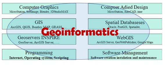
Geoinformatics is a field of technology that provides integration and analysis of spatial data. The storage of spatial data in relational databases started with the new BLOB and SDO_Geometry data types. Such data storage enables the integration of spatial data with descriptive data
