
The aim of the project is research of the remote sensing data integration for control procedure in the system of direct payments in agriculture (IACS - Integrated Administration Control System).
In order to obtain subsidies, the farmer declares the type of crop and its area. The accuracy of this information is controlled in the IACS system. Until now, the inspection was carried out during the field visit, or partly remotely, among others with the use of aerial photos processed into the so-called orthophotomaps, such as Google Maps.
As a result of intensive EU activities under the Copernicus program, which aimed to create a satellite system competitive to the American Ladsat system, a group of Sentinel satellites was created. The first satellite of this group Sentinel-1 was placed in orbit in 2014 and by intended for radar registration, the second - Sentinel-2, registering in the visible and infrared range was launched in 2015. The parameters of the Seninel-2 system are better than those of the Landsat system in in every range: greater spatial and spectral resolution and more frequent revisits, which is crucial in our climate.
Since then, one can observe a very large interest in the use of data from the Sentinel group in various fields. The number of research projects in which these images are used has increased, various portals are created to share Sentinel images with their processing products.
The main advantage of Sentinel-1 and 2 images is their relatively high spatial resolution and frequency of recording, which is of key importance for Poland.
Recently, the EU plans to replace the so-called on-site inspection, consisting of GPS or orthophotomap measurement and determination of crop types during a site visit, remote sensing measurement using the new products of the European Space Agency (ESA) of the Copernicus program, i.e. the Sentinel-1 and Sentinel-2 images. On the initiative of the EU research center (JRC, Ispra, Italy, MARS Unit), which is a support for the Common Agricultural Policy, recommendations were made regarding the use of Sentinel images in IACS control.
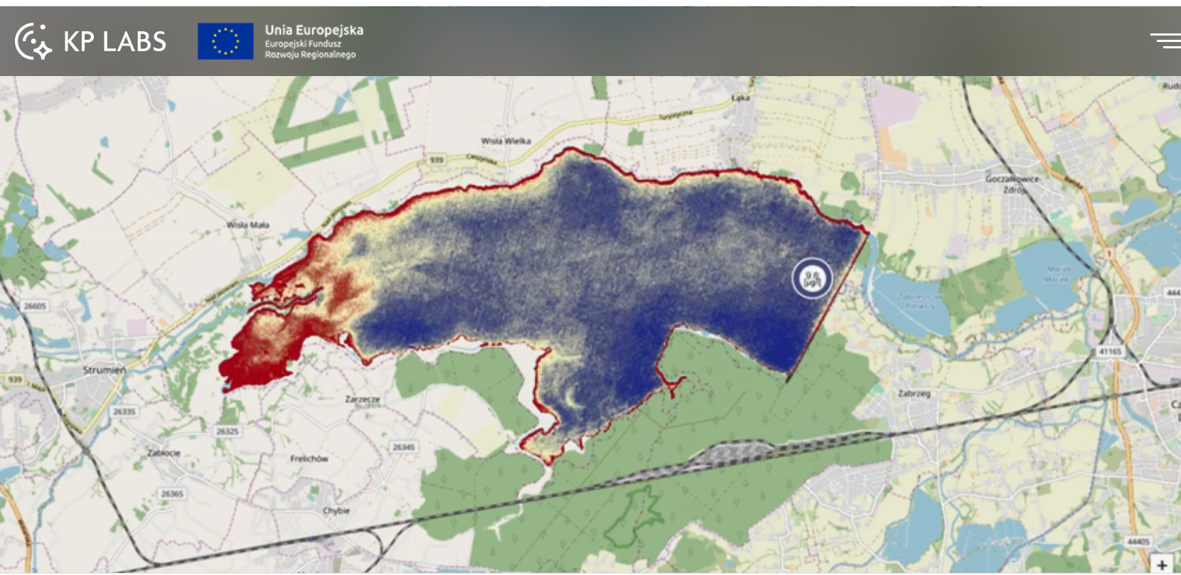
As proposed by the JRC, research was carried out in Polish conditions, confirming the difficulties in using this data, especially for small plots of land in southern Poland (projects 1, 2). The results of the project carried out in 2018 (2) partly confirmed the possibility of using the proposed methodology in northern Poland. Based on the research work carried out by the GPRSE research team in 2018, it appears that determining the type of crop is in most cases possible, whereas plant detection is a problem. Another limitation is the size of the parcel in the context of images whose field pixel size is 10 m, which prevents effective detection of the crop border in the case of small plots (e.g. in the south of Poland, Italy, Greece). In 2019, the GPRSE WG performed research using hyperspectral images from the satellite and air level. Unfortunately, due to the inability to take current pictures, archival data obtained under another project and free data were used. As a result of this project, using our own methodology, better results were obtained than using the approach recommended by JRC. The potential for aerial hyperspectral imagery is much greater than we could demonstrate under the project in 2019.
Therefore, as part of this application, we would like to apply for funding the following activities: - airborne images acquisition from the medium and low altitude using a drone with multi- and hyperspectral cameras - developing a methodology for integrating hyperspectral and scanner data from the airborne level with satellite data Sentinel-1 and Sentinel-2 - implementation of the developed solution using Google Earth Engineering tools
Finally, we plan to apply to the National Center for Research and Development or H2020 to create a center of excellence in Geospatial Data Processing (PDG). The platform would integrate the ability to meet the needs of various other areas, e.g. archeology, history (CHT2 project) or for reservoirs water quality monitoring (AMMER project). Many other specific areas of interest can be mentioned. The idea of the CDP center would not only be to provide new products to a wide range of end users (farmers, ARIMR ...) but also to researchers who would be able to conduct research using a variety of data not only Sentinel, what is the limitation of most exixting solutions.
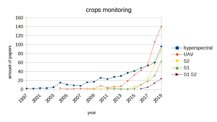
The proposed actions seem purposeful in the context of the interest of researchers in the world. Using SciVal / Scopus to analyze publications concerning hyperspectral imaging and drones (UAV - unmanned aerial vehicle) using in crop monitoring, a rapid increase in the number of publications (10x) compared to 2015 can be observed in 2019. In turn, analyzing projects implemented in the framework EU programs from the CORDIS database in the years 1986-2020, it turns out that about 75% of projects regarding the use of remote sensing in monitoring of crops ("remote sensing crop monitoring") fall in 2015-2020.
The third signal that this topic should be addressed is the high activity of various research centers in the world and in Poland in the field of creating internet solutions using ESA satellite images, including mainly Sentinel (Sentinel-hub Playground, esa-sen4cap, Copernicus DIAS (CREODIAS, mundi , sobloo, Wekeo, ONDA), Landsat App, CENAGIS and others). It should be noted that before 2015 there were no such services at all. It can be said that now is the right time to take action in this direction, because on the one hand the Sentinel system is in a stable, operationally mature phase, various similar solutions have already been created, thus confirming the legitimacy of research in this direction. Besides there are still areas where this approach can be implemented.
Current achieveements:
2001, Co-authorship of recommendations for the Land Parcel Identification System (LPIS) in the Integrated Administration Control System (IACS) for the purposes of financing direct payments to agriculture - the phase before Poland joins the EU, project (6) 2005
Co-creation of the basics of validation methods for parcel area measurements, projects funded by the EU research center, JRC, Ispra, Italy (MARS Unit), projects (3, 4, 5) 2010
Creation of a reference laboratory for validation measurements of GNSS devices and orto images for the needs of IACS control 2012
Monograph "Validation of GNSS receivers for the purposes of controlling the size of agricultural parcels area in the direct payments system for agriculture IACS: guidelines, application, problems" (Kramarczyk et al. 2012)
Initiation, planning, participation in the performance of Proficiency test (PT), in accordance with PN-EN ISO / IEC 17043, 3.7, validation methods for measuring agricultural plots. The results were presented in the publication [(Hejmanowska et al. 2012)] (http://publications.jrc.ec.europa.eu/repository/bitstream/JRC73275/lbna25533enn.pdf)
2015, Impact of the PT project - amendment of EU regulations consisting in simplification of control provisions, which was introduced in the EU Regulation (809/2014, Art. 38 point 4), allowing from 2015 to adopt a uniform buffer size of 1 m during control measurements surface. The new regulation amended the previous EU Regulation No. 1122/2009 (Art. 34 point 1), establishing a maximum tolerance of 1.5m (in the Polish version of this point there is an error in relation to the English version). In practice, this requirement was specified in the JRC recommendations setting different tolerances for different measuring methods from 0.5 - 1.5 m. On the one hand, tolerances were established based on quasi-laboratory measurement, on the other hand, too high precision requirements that were impossible to meet were introduced. Both hypotheses made before the experiment was confirmed and led to the abovementioned changes in regulations. [Related documentation can be found on the MARS UNIT JRC website] (https://marswiki.jrc.ec.europa.eu/wikicap/index.php/Main_Page)
15.06.2019 - 15.12 2019 The use of hyper-perspective data to monitor the agricultural activity of the ARMA beneficiaries and support its business processes, research project financed by the ARIMR, project manager: E. Głowienka - password required: e-mail galia@ag.edu.pl
15.09-15.11.2005: Validation of methods for measurement of land parcel areas - near-VHR imagery, supplementary study to the service contract No 22581-2004-12F1SC ISP P, 2006, project manager: B. Hejmanowska
2001: Elaboration of assumptions for building up of National Land Parcel Identification System (LPIS) as an element of Integrated Administration and Control System (IACS), Samecki 5 - PHARE - PL - PAO / AGR, 2001, main contractor: B. Hejmanowska
Experience in other international projects whose results can be implemented in the center of PDG / GDP excellence
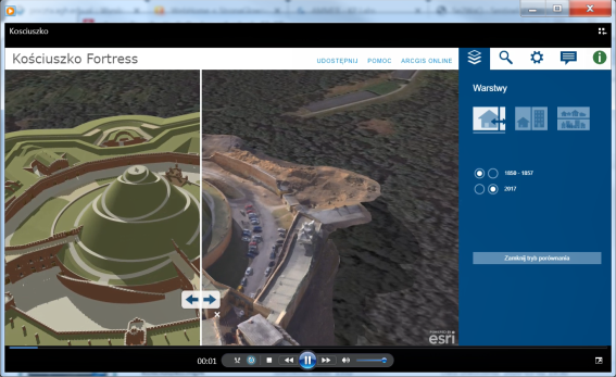
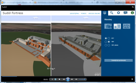
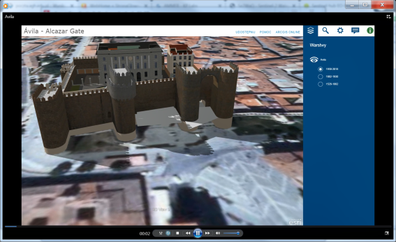
CHT2 The project: Cultural Heritage Through Time (CHT 2) was carried out by an international consortium (IT, UK, ES, PL). Information on the project can be found on the project leader's website: http://cht2-project.eu/ and on the team's website: https://cht2.eu/index.php. The aim of the project was to integrate 3D models of buildings, cities, and landscape for the needs of use in works related to monitoring and preserving the national cultural heritage. A description of the results and a detailed report on the project in Polish and English can be found at (https://cht2.eu/index.php/About-project). The Polish partner, SSSA, was responsible in this project, in addition to tasks related to the creation of 4 D models for selected forts of the Krakow Fortress, mainly for publishing 4 D models on the Internet. The result is the internet application: https://cht2.eu/index.php/ONLINE-VISUALIZATION, which has 4D models available on the Internet for all project partners. Storna is constantly updated based on emerging new models. Noteworthy is the interdisciplinary composition of the team working in the project, consisting in addition to specialists in civil engineering also scientists in computer science, archeology and history. The impact of the knowledge of specialists in non-technical fields was not to be overestimated due to the subject of research, i.e. the historical context.
AMMER In the period from 01/01/2018 to 31/03/2019, the research team implemented the ESA project on water quality monitoring of inland reservoirs (AMMER: Automated Method for Measuring Eutrophication of Inland Water Using Remote Sensing). The project was managed by the FP Space Consortium, the partners of the project were the Central Mining Institute and the Scientific Association of St. Staszica (head of the research team: B. Hejmanowska). As a result of the project, an internet application was created: https://www.kplabs.pl/en/ammer/, in which the results of the research were implemented. As part of the research, algorithms for calculating chlorophyll-a based on satellite images of Sentinel-2, ESA were developed. The algorithms have been developed for 12 tanks in the Śląskie and Małopolskie voivodships. The application is based solely on remote sensing data from the Sentinel-2 satellite and, due to frequent image recording, allows very dense monitoring of water quality in tanks. The use of free data (Sentinel-2) and a web application allows for much easier and cheaper determination of phytoplankton concentration in water due to the lack of the need to perform, time-consuming and expensive laboratory tests. The second advantage is the possibility of obtaining a spatial image of the phytplangton concentration distribution in the tank area, and not one concentration value at the measuring point.
Impact:
Development of an alternative to JRC crop control method, applicable in Polish conditions, based on a hierarchical approach "from general to detailed": -screening analysis based on crop type, Sentinel-1 and 2 images and on crop boundaries on the LPIS system -determination of crop type and course on the basis of multi / hyperspectral images from the aviation ceiling -control using drones in inaccessible places
Implementation of the developed approach on the GEE platform
Piotr Kramarczyk, supervisor: dr hab. inż S. Mikrut. Scientific interests concern control in the IACS system (monograph Kramarczyk et al. 2012), testing algorithms using new data and their implementation in Google Earth Engine (GEE) tools.
Adrian Moskal, 2 year doctoral studies, supervisor: dr hab. inż. S. Mikrut, drone flights under the supervision of a supervisor (both persons have licenses to perform drone flights).
Anna Żądło, tutor: prof. dr hab. Eng. Beata Hejmanowska, title of the research topic: The use of machine learning to automate the analysis of large remote sensing data sets. The role of the PhD student will be processing image data, such as BigData, for implementation in GEE.
Karolina Pargieła - tutor dr hab. inż. U.Marmol, title of the research topic: Research on optimization of data acquisition and processing from unmanned aerial systems for the purpose of measuring objects with complex geometry. The role of the PhD student will be research on the possibility of increasing the accuracy of the results of qualitative and quantitative analyzes for arable areas, thanks to the integration of remote sensing data with low and high altitude photogrammetric data as well as data from aerial laser scanning.
2001: “Elaboration of assumptions for building up of National Land Parcel Identification System (LPIS) as an element of Integrated Administration and Control System (IACS)” , Samecki 5 – PHARE – PL – PAO/AGR, 2001, expert in photogrammetry and GIS
22.11.2006 – 31.03.2007: “Estimation of the measurement error of parcel areas measured on VHR SAR data”, Joint Research Centre (JRC), Ispra, Italy, 2006, project coordinator
12.02 – 30.06. 2017 - "External quality control under digitalisation of land parcel identification system", Turkey - Agrotec S.p.A. as Senior LPIS Expert