 Introduction |
Equipment |
Denmark |
Route |
Expedition |
About us

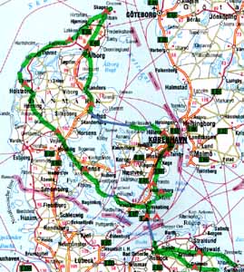
During our sixteen days expedition we crossed over 1900 kilometres, most of which obviously in Denmark. The whole thing started in Swinoujscie, which we reached by train. Then, already on bikes, we got to Rostock from where we took a ferry to Gedser where cycling on Danish soil started. We took the direction north, crossed Falster and Mon Islands and, following the west coast of Danemark, got to Copenhagen. From there we set off in the north-west direction to get back to the continent. From Arhus we went directly to Skagen, the most northern point of Denmark and the main goal of our expedition. We left Skagen cycling alongside the northern coast of Denmark and after reaching its western end we said 'goodbye' to the North Sea and started getting back in the south-east direction. In Fredericia we left the continent to find ourselves in the Fyn Island and then on the small islands of Tasinge and Langeland. On the last one we took a ferry and got to Nakskov which we left in the following the east direction. Shortly we got to Falster, where the loop of Denmark was closed. The last section, from Nykobing to Gedser we already knew very well from the beginning of the expedition. A ferry to Germany, Rostock, the east direction. Finally Altwarp, a ferry over the Szczecin Lake, Polska, and here we are, back at home.
This was our expedition in brief. You can follow it on the joint map. The blue lines stand for the ferries we took. The small red tent symbols symbolise our shelters. And the thick green line is the route we crossed in the saddles.